


Syndication
The Lake Traverse Reservation, home to the Sisseton Wahpeton Oyate, doesn’t appear on official South Dakota state maps.
Literally, the oyate (a Dakota word meaning “people” or “nation”) was wiped off the map because of a 1975 U.S. Supreme Court decision.
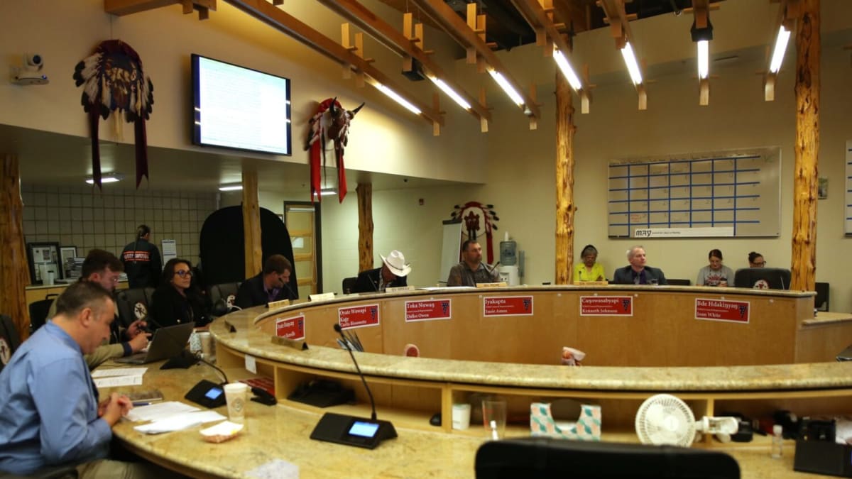
That decision has made tribal members feel erased in the last 50 years, tribal council members told the State-Tribal Relations Committee at the tribal headquarters Monday in northeastern South Dakota. But Sisseton Wahpeton is alive – its culture and government – and tribal leaders say its boundaries are intact, even if official maps don’t recognize it.
The tribe has been working to resolve the issue for years, with the only options being to take the issue to the Supreme Court again or have Congress federally recognize and reestablish the reservation boundaries. The boundaries encompass a triangular-shaped reservation with 107,200 acres of land.
The first step is having the South Dakota Legislature recognize those boundaries in its own legislation before taking the issue to Congress, tribal council members said.
“This is a part of our treaty and something that’s recognized on a federal level,” said Rep. Tamara St. John, R-Sisseton, and a citizen of the Sisseton Wahpeton Oyate. “Although this is a big issue, what we’re asking for is relatively small. It is the understanding that we’re still here.”
St. John has already drafted legislation for the 2024 legislative session, which will convene in January, to recognize the treaty boundaries. She stressed that the draft isn’t complete.
“We have work to do,” St. John said. “This is a first step in wanting you all to be aware and ideally support us as we move this forward.”
The South Dakota State-Tribal Relations Committee is a legislative committee filled with lawmakers responsible for fostering relationships between the state government and South Dakota’s nine tribal nations.
If the Legislature passes the bill, it would be the first major step in a decades-long battle for Angelique EagleWoman, a professor of law at the Mitchell Hamline School of Law, director of the Native American Law and Sovereignty Institute and chief justice of the Sisseton Wahpeton Oyate Supreme Court.
The Lake Traverse Reservation was created by a treaty between the Sisseton Wahpeton Oyate and the United States in 1867, 22 years before South Dakota became a state. The tribal nation ceded over 25 million acres of land to the United States from 1805 until the reservation boundaries were officially established in 1867.
In 1975, the Supreme Court made a 6-3 decision in DeCoteau v. District County Court to disestablish the reservation boundaries. The decision cited an 1891 agreement between the Sisseton Wahpeton and the U.S. government to open the reservation to non-Native settlers within its boundaries. A dissenting opinion argued that there wasn’t any indication in the agreement that the reservation boundaries were altered or disestablished.
While the U.S. Congress did pass a federal law recognizing the reservation existed after the 1975 decision, it was limited to allotments and tribal lands within the original boundaries, EagleWoman said, and did not provide the full federal recognition needed of its 1867 boundaries.
EagleWoman urged the lawmakers to support the legislation next session as “a matter of justice, fairness and doing what is right.”
“This is ongoing and we’d like to put it to rest so we can start focusing on things we need,” EagleWoman said.
The official map of South Dakota’s state highways also omits the Yankton Sioux Reservation and the Flandreau Santee Sioux Reservation. According to an article in the Lakota Times by the Center for American Indian Research and Native Studies, the state Department of Tribal Relations said Flandreau isn’t included because it is an “area of influence” instead of a reservation, and Yankton is not shown because its boundaries are “undefined.”
The Yankton and Flandreau boundaries were not addressed during Monday’s meeting.
We provide the independent reporting that non-Native, extractive outlets often overlook. We give our communities the context and the facts they need to make informed decisions.

Respect The Fire
At Buffalo's Fire, we value constructive dialogue that builds an informed Indian Country. To keep this space healthy, moderators will remove:
- Personal attacks, harassment, or hate speech
- Spam, misinformation, or unsolicited promotion
- Off-topic rants and excessive shouting (All Caps)
Let’s keep the fire burning with respect.